


Geodatabases
FEFLOW 8.0 supports the import of information from Geodatabases PostGIS, Oracle and ESRI. Connecting to ESRI Geodatabases is only possible with the 32-bit version of FEFLOW and with an adequate ESRI license.
 |
Export into an existing table/feature class erases all previous content of the table/feature class. The export option cannot be used to append information to existing tables! |
Database Connection
The connection to a Geodatabase is managed through a FEFLOW Database Connection File (*.fedb). The connection file contains all settings for the connection to a specific geographic database, i.e., information on the host, port name of the database, user name and password.
Connect to a Database
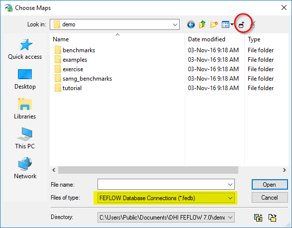
An existing connection file can be opened via
 Add
Map (s). in the context menu of the
Add
Map (s). in the context menu of the  Maps
panel or by clicking on the search icon in the panel. Creating a new
connection file or editing an existing one is possible via the file-selection
dialog evoked via Add Map or
the search option in the Maps
panel. Make sure that the displayed file types in the file-selection dialog
include the format *.fedb.
Maps
panel or by clicking on the search icon in the panel. Creating a new
connection file or editing an existing one is possible via the file-selection
dialog evoked via Add Map or
the search option in the Maps
panel. Make sure that the displayed file types in the file-selection dialog
include the format *.fedb.
After this step, the procedure differs depending on the type of database:
PostGIS and Oracle
For PostGIS and Oracle databases, the Open PostGIS Table and Open Oracle Table dialogs are opened. In the upper part, it provides an overview of the Connection Properties. In its lower part, there are two options:
- Via Open existing table one of the database tables can be selected for opening.
- Alternatively, a User-defined
query can be specified to derive data from the database. The
first line defines a query name (used as the feature name for display
in the Maps
panel), the second line is for the SQL query itself. The syntax is
SQL and the Verify button is
used to check the syntax and to list the available columns for choosing
the one with geometry information. To obtain geometries from the database,
a Geometry
column needs to be chosen, specifying which column in the query
results shall be used as geometry information.
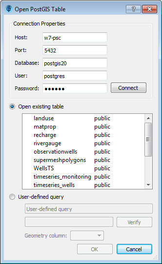
Open PostGIS Table dialog.
ESRI Geodatabase
For ESRI Geodatabases, the standard Open ARCGIS Table or Feature Class dialog is brought up after opening a FEFLOW Database Connection File. Here, it is possible to select a feature class from the database.
Create a new Database Connection
The file selection dialog brought up when choosing
Add
map from within the Maps panel
provides functionality to create and edit FEFLOW Database Connection (*.fedb)
files:
 |
Add database connection. Active when FEFLOW Database Connections (*.fedb) format or All Maps is selected in the Files of type line. |
 |
Edit database connection. Active when FEFLOW Database Connections (*.fedb) format or All Maps is selected in the Files of type line and an existing database connection file is selected in the file list. |
Adding a database connection.
When creating or editing a connection file, the available options differ according to the database type:
PostGIS Connection
| Property | Description |
|---|---|
| Host | Hostname or IP adress of the host the DB is running on, 'localhost' for local DB |
| Port | DB port |
| Database | Name of the DB |
| User | DB user name |
| Password | DB user password |
| Connect | Test connection |
| Save Password | Check to save the password in the *.fedb file |
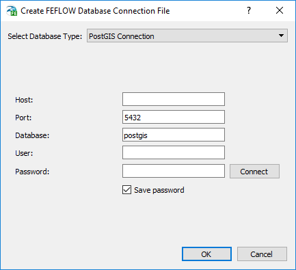
Creating a *.fedb file for PostGIS.
Oracle Connection
Connections to Oracle databases with Oracle Spatial can be established either directly or via a Net Service connection.
| Direct Connection | Host | Hostname or IP adress of the host the DB is running on, 'localhost' for local DB |
| Port | DB port | |
| Service | Name of the DB Servce | |
| Net Service Connection | Net Service Name | Name of the Net Service to be used for connection |
| User | DB user name | |
| Password | DB user password | |
| Connect | Test connection | |
| Save Password | Check to save the password in the *.fedb file | |
ESRI Geodatabase
The import of maps from different kinds of ESRI Geodatabases (Personal GDB, File-based GDB, ArcSDE systems) is based on ESRI components and thus requires an adequate ESRI license. It is only supported in 32-bit FEFLOW as the corresponding ESRI components are only available in 32-bit. Export into ESRI Geodatabase is currently not supported.
Creating or editing the database connection, the Path to an ESRI Workspace has to be provided. The Type is determined automatically. To input a workspace location, the standard Open ARCGIS Workspace dialog can be opened through the ... button.
Export to a Database
The export to a Geodatabase, for example from
within the Data
or View
Components panels, is very similar to the import, also relying
on *.fedb files containing the connection
properties.
Within the Save Oracle Table and Save PostGIS Table dialogs, an existing table/feature class has to be selected, or a new name has to be input to create a new table.
 |
Export into an existing table / feature class erases all previous content of this! The export option cannot be used to append information to existing tables. In ESRI geodatabases, existing attribute columns will be maintained, but all existing features will be deleted |